Extent and boundaries
James Anderson’s c.1835 New Statistical Account describes a parish about six miles and two furlongs from north to south and gives an area of 4,170.792 imperial acres (also 3,307 Scots acres). The c.1885 Ordnance Gazetteer gives 4,027 acres and places the parish in north-west Lanarkshire, bounded by neighbouring parishes. The sources therefore report different areas; neither value should be silently preferred until original printings, measurement conventions and boundary changes are compared. New Statistical Account · Ordnance Gazetteer
The Clyde forms the north-eastern edge described by the gazetteer, while the Rotten Calder defines much of the west. The New Statistical Account also describes the Calder and smaller streams, linking settlement and industry to watercourses. From the low Clyde margin, the land rises southwards; the historical descriptions refer to varied soils and Carboniferous strata, including limestone, sandstone, coal and ironstone. This physical setting helps explain both water-powered textile development and later mineral extraction, but individual works and mines belong to their own histories. New Statistical Account · Ordnance Gazetteer
Parish boundaries and administrative use
The historical parish was a geographic and ecclesiastical unit before it became part of Scotland’s statutory poor-law administration. Under the Poor Law (Scotland) Act 1845, parochial boards administered relief; the Local Government (Scotland) Act 1894 replaced that system with parish councils, and the 1929 reorganisation ended their local-government role in 1930. The National Records of Scotland describes civil parishes as administrative from 1845 to 1930 and retains later boundary geometry as a historical GIS layer. This sequence does not mean the pre-1845 parish was created in 1845, nor that the modern town or Ward 15 shares its exact extent. A separate 1598–99 charter described Blantyre as a burgh of barony, while a police-burgh proposal was discussed in 1893; neither legal term should be read as a synonym for the parish. Blantyre local government history Poor Law (Scotland) Act 1845 · Local Government (Scotland) Act 1894 · NRS civil-parish layer
Ecclesiastical and civil boundaries
The historical parish cannot be mapped by treating every later church parish as a new civil parish. Scotland’s People distinguishes the old quoad omnia parishes, which historically served church and civil purposes, from later quoad sacra parishes created for Church of Scotland worship. Its national guide states that a quoad sacra parish’s boundaries did not replace the parent civil parish boundary. The 1952 account says Stonefield’s quoad sacra parish was formed in 1889; a later register compilation gives 24 February 1890 for disjunction from Blantyre. Those may be stages in the church arrangement, but the cited sources do not establish the legal sequence or a Blantyre civil-boundary change. The broader civil-parish revision of 1889–1929 was a distinct administrative process. Blantyre local government history Stonefield, Blantyre Scotland’s People, “Parishes and districts”
Population and changing census geographies
Published census summaries show the parish’s scale during the mining-era expansion, but must be read with attention to census date and boundaries. The official 1911 report gives 14,145 for the civil parish in 1901 and 16,821 in 1911; an indexed reconstruction of 1891 Table 1 reports 11,352 in 1891, but its original table and boundary notes still require direct checking. The 1952 parish account repeats 14,145 for 1901, while a later local-history post gives 17,505, an unresolved discrepancy. Separate police counts reported for 1902 and 1924 are not treated as equivalent to decennial census totals. Blantyre population, 1755–1951 census of scotland 1911 parish population vision of britain 1891 blantyre parish table
Settlements and localities
The c.1885 gazetteer distinguishes Blantyre village (also High Blantyre or Kirkton), Blantyre Works (Low Blantyre), Auchinraith, Auchintibber, Barnhill and Stonefield. It gives relative positions and describes them as separate villages or localities within the parish. The labels are historical descriptions rather than fixed modern neighbourhood boundaries: later urban expansion joined formerly separated communities and altered how residents use the names. The available textual sources do not provide polygons precise enough to map each locality confidently. Ordnance Gazetteer
These settlement distinctions matter for interpreting local history. High Blantyre/Kirkton is associated with the parish church and priory landscape; Low Blantyre grew around the cotton works and workers’ village. Stonefield, Auchinraith and Barnhill feature in the later expansion of housing and mining communities. Their individual histories are covered in High Blantyre, Low Blantyre and the Works village, Stonefield, Blantyre and Blantyre Colliery.
The parish on an 1860s Ordnance Survey sheet
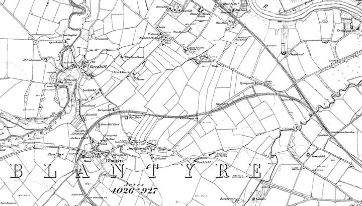

Land use and change
The New Statistical Account describes agriculture, farms and an industrial landscape already altered by cotton manufacture. The later gazetteer records coal and ironstone workings and gives a much larger historical population than the account’s early nineteenth-century totals. The Third Statistical Account (1952) retrospectively describes the transition through coalfield growth, housing, industrial decline and newer development. Those accounts come from different dates and purposes; they document changing views of the parish but do not by themselves settle exact settlement boundaries or population comparability. New Statistical Account · Ordnance Gazetteer · Third Statistical Account
The parish landscape is also layered with earlier and later institutions: Blantyre Priory overlooks the Clyde; textile settlement developed at Blantyre Cotton Works and Works Village; mineral railways and collieries reworked upland land. The map index historical maps identifies the next research step: compare parish plans and successive Ordnance Survey editions to locate shifting built edges, routes, pits and lost settlements.
The Third Statistical Account, written by the Rev. A. Mackenzie in 1952, describes the parish’s historical edges in a compact physical-geography summary: the Clyde bounded it to the north and north-east, Rotten Calder burn formed the west boundary, Bothwell and Hamilton lay to the east, and Glasford to the south. It calls the Clyde and Calder banks wooded but notes the spread of coal bings across lower-parish land. The same passage prints the parish area as “3.885 acres”; because the figure’s notation or transcription is unclear, it is retained as printed rather than silently normalised. Comparison with other accounts (which give approximately 4,027 to 4,171 acres) requires a boundary and measurement audit before using any one area for density calculations. third statistical account blantyre 1952 Blantyre population, 1755–1951 (Third Statistical Account: Parish of Blantyre (1952))
Archaeological landscape around Calderside and Auchentibber
The western parish fringe preserves a different evidence mix from the Clyde-side industrial village. A 2025 cultural heritage assessment for a proposed solar development describes the Calderside fields as chiefly agricultural, with scattered post-medieval extraction and processing: ironstone pits, limekilns, former field boundaries and farmsteads. Its comparison of Roy's Military Survey with the 1864 Ordnance Survey places occupation at Auchentibber before the later agricultural-improvement period; surviving courtyard buildings include several phases, with some fabric assessed as late eighteenth or early nineteenth century. These survey findings document the landscape's recorded traces, but the commissioned report is not a complete archaeological inventory and later fieldwork results remain to be checked. Auchentibber farmstead Calderside Solar proposal and Blantyre's northern landscape Cultural Heritage Impact Assessment, pp. 23–25, 48–52
The same assessment records the ambiguity of older prehistoric and antiquarian claims. It reproduces Canmore records for cists and urns reportedly found in the parish, while warning that their plotted positions are approximate and cannot establish that the finds were within the modern development boundary. At Craigmuir it records an unconfirmed interpretation of a cropmark as a castle, but reports no supporting evidence from its walkover and notes possible mining-related explanations. The historically named Camp Knowe, Blantyre was described in an 1885 gazetteer as a Caledonian fortification; in 2025 a field observer described its visible ridge as natural-looking. Neither wording alone resolves the feature's origin, and the separate records for an earthwork and subterranean structure require individual examination. Prehistoric and archaeological sites of Blantyre Calderside assessment, pp. 23–25, 42, 48–52 · Ordnance Gazetteer, 1885
The parish described in 1846
Samuel Lewis’s contemporary gazetteer gives the parish as six miles long from north to south, averaging less than a mile in breadth, and 4,170 acres. It describes the Clyde as a boundary with Bothwell for about three miles and the Rotten Calder along the west, joining the Clyde near Daldowie. It names Redburn rising at Park Farm and entering the Clyde near Bothwell Bridge, with other streams rising at Shott and Newmain. The account calls the parish wooded and undulating, with loam, clay, sand and moss soils; it says drained former common land at Blantyre Moor had been divided and brought into cultivation. These are dated landscape descriptions, not a modern hydrological or cadastral survey. Its area (4,170 acres) is close to, but not identical with, the 4,170.792 acres in the c.1835 account and differs from later gazetteer values; the boundary basis and measurement methods remain unresolved. lewis topographical dictionary blantyre 1846 Historical maps of Blantyre Lewis, 1846
The New Statistical Account provides a direct distinction important to this parish landscape: it places a cist uncovered “about three years” before c.1835 at Shott, near the parish church, and separately locates six larger urn fragments in a field called Arches or Archer’s Croft. It also describes Camp Knowe as a 600-foot-circumference hill said to have been ditched, with a recently discovered flagstone subterranean structure nearby. These are contemporary antiquarian descriptions rather than modern archaeological determinations. A later planning statement quoting WoSAS assigns a cist to Archer’s Croft in 1826 and cites Name Book dates of 1826 and 1842; this may be an additional discovery or a later conflation. Until the original Name Book and underlying record are compared, the Shott and Archer’s Croft contexts should remain distinct. New Statistical Account, pp. 320–21 · Malcolmwood planning statement, pp. 47–48 Malcolmwood Farm battery storage proposal the archaeological-sites account Malcolmwood planning statement, pp. 47–48
Related
- stonefield parish fasti chronology
- nls historic maps parish viewer
- ordnance gazetteer blantyre 1885
- Prehistoric and archaeological sites of Blantyre
- Camp Knowe, Blantyre