Foundation and affiliation
HES places the foundation in the first half of the thirteenth century and says it was probably endowed by Patrick, Earl of Dunbar, and his wife. The community followed the Augustinian order and the house served as a cell of Jedburgh Abbey. Historic Environment Scotland dates construction of the parent abbey to approximately 1138–1300 and places its foundation within David I’s programme of Augustinian establishments; that chronology provides context for the Clyde-side cell but does not establish its own foundation date. The c.1835 New Statistical Account instead attributes the foundation to Alexander II, while admitting that little could be established about its early history. The available evidence supports an early thirteenth-century foundation and probable Dunbar patronage, but does not establish the founder conclusively. The Alexander II attribution records nineteenth-century understanding rather than an equally detailed modern assessment. HES · New Statistical Account
The priory’s opposite-bank relationship with Bothwell Castle is geographical, not evidence of common patronage. HES specifically notes that Bothwell Castle was not held by the families who endowed the priory. The Clyde crossing and valley connected the two sites while their institutional histories remained distinct. The priory’s affiliation with Jedburgh Abbey also places it within a wider monastic network beyond Lanarkshire. HES
Buildings and landscape
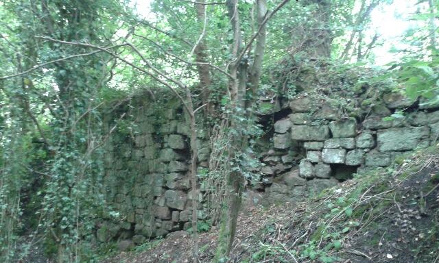
The surviving monument comprises ruinous masonry and earthworks. HES describes a group about 30 metres north–south by 12 metres across at the eastern edge of the site. The northern building has been identified as the prior’s house; to the south are a small courtyard and traces of at least three further stone buildings. A larger courtyard or garth occupies higher ground to the west. Rough sandstone boundary walling survives on the north, west and south sides, with a ditch and outer bank beyond part of the western wall. The church’s precise position has not been securely identified. HES designation
Topography shaped the plan. Steep ground and cliffs to the north and east helped enclose the precinct and made its buildings conspicuous above the river, while the limited level ground concentrated the main structures along the cliff edge. The higher ground to the west accommodated the garth. HES considers the buried archaeology potentially capable of clarifying the plan, construction sequence, use and abandonment; these are research possibilities, not established excavation results. The location also belongs to a larger Clyde-side landscape whose later industrial transformation is traced in Blantyre Cotton Works and Works Village. HES
View of the surviving masonry

Reformation and later residence
HES’s historical summary says the priory remained in religious use until the Reformation in the later sixteenth century. It was secularised in 1599 and passed to the Stewarts, who adapted the buildings as a private residence. Lady Blantyre and her daughters left in 1606, leaving Lord Blantyre; the date when the site was finally abandoned is not known. This sequence shows reuse rather than a single, precisely dated end to occupation. The available designation account does not establish how much of the medieval plan survived those domestic changes. HES designation
Archaeological record and visual documentation
Trove’s HES/RCAHMS record identifies the place as Blantyre Priory at Blantyre Farm Road, parish of Blantyre (Hamilton), grid reference 268605, 659381, and catalogue reference NS65NE 6. It records a 1953 Ordnance Survey visit and lists later photographs of the north wall (DP 241812 and DP 241813), as well as 1958 OS index cards. The catalogue identifies a 1953 Ordnance Survey visit, north-wall photographs DP 241812 and DP 241813, and 1958 OS index cards. These records complement the designated site description and document later survey activity. Trove record 44890
The South Lanarkshire Council nature-reserve statement places the ruins at NS 68597 59382 and treats them as one of several heritage features embedded in the Clyde corridor. It describes the reserve’s industrial transformation around the priory landscape: agricultural land and estate features were followed by mining spoil and workings at Priory Bing, which remained visible into the late 1960s. The council’s management plan provides landscape context; the building plan and medieval features are described in HES’s monument designation. Council management statement
Related
-
trove scot blantyre priory record
-
historic environment scotland blantyre priory
- The historical parish of Blantyre