
Origins on the Clydesdale route
The station developed on the Clydesdale Junction Railway’s Glasgow–Hamilton route. RAilScot dates the line’s authorisation to 1845, the opening of the Glasgow–Hamilton branch to 1 June 1849, and Blantyre’s opening as an intermediate station to 17 September 1849. The Clydesdale Junction Railway was absorbed by the Caledonian Railway in 1846 before the line opened. RAilScot, Blantyre station · Blantyre Project, railway crossing
The 1885 Ordnance Gazetteer places Blantyre station near Blantyre Works or Low Blantyre, on the Clydesdale section of the Caledonian Railway. It separately locates High Blantyre’s station on the Strathaven branch. This distinction is important for interpreting nineteenth-century population descriptions: “Blantyre station” in a Low Blantyre industrial account does not refer to the station beside the parish kirk. Ordnance Gazetteer, c.1885 · Low Blantyre and the Works village · High Blantyre railway station
An 1844 National Records of Scotland catalogue record describes Joseph Locke’s plan and section of the Clydesdale Junction Railway through Blantyre parish to Hamilton. It identifies fields, roads, buildings, parish names and limits of deviation on the plan. The catalogue establishes the plan’s subject and date; it is not evidence for a specific property or alignment without examination of the map itself. NRS catalogue, RHP24943/1/4 · historical maps
Station rebuilding and local access
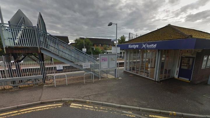
Local railway-history accounts report that the original station structures were rebuilt in 1899: platforms were raised by 13 inches, both were widened, and new lighting and fencing were installed before replacement buildings opened around 1900. The same account describes further replacement buildings in the early 1980s. The Caledonian Railway Association catalogue lists five 1899 proposed-reconstruction drawings and a 1915 High Blantyre station reconstruction/track-layout plan; these records document proposed designs. CRA station plans · CRA track plans · Blantyre Project, “New Station, 1899” · Glasgow Road, Blantyre
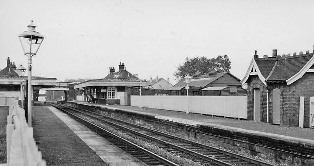
A local-history article identifies a photograph as Blantyre station in the 1920s, though the date is approximate. Ben Brooksbank’s photograph records the present station on 6 October 1961, looking north-west towards Newton and Glasgow. It is distinct from the former station at High Blantyre. The Commons file record identifies the 1961 photographer and image. Blantyre Project, 1920s photograph · Ben Brooksbank, 1961 photograph
Park and ride, accessibility and town-centre access
South Lanarkshire Council’s 2018–27 Park and Ride Strategy contains more than one snapshot of parking at Blantyre station. Its summary describes 60 spaces in 2017, while Appendix B’s table separates a 51-space ScotRail car park from a 58-space SLC car park, both recorded at full occupancy. A site visit by AECOM on 20 February 2017 observed both lots full and overspill parking on nearby streets; the SLC lot was about 200 metres north of the station. The same appendix says 60 spaces had been added to the SLC lot in 2014, a detail that does not reconcile directly with the listed 58-space inventory. The report’s different totals should therefore remain attributed and dated rather than combined into a false continuous count. Council Park and Ride Strategy and appendices (South Lanarkshire Council, Park and Ride Strategy 2018–2027) · Appendix B (South Lanarkshire Council, Park and Ride Strategy 2018–2027 appendices)
The 2018 study analysed Blantyre with Hamilton West and Hamilton Central in a station zone and cautioned that measures at one station could affect the others. It reported 610,730 passenger footfall in 2015–16, 5.3 per cent average annual passenger growth over the historical period analysed and 4.2 per cent zone growth; its cited 2011 Census figure said 6 per cent of Blantyre-locality residents travelled to work or study by train. The study projected demand for up to 37 additional spaces by 2023. These are planning-era measures and forecasts, not current patronage or proof that the forecast was realised. Council appendices (South Lanarkshire Council, Park and Ride Strategy 2018–2027 appendices)
The council appendix records two cycle lockers, two Sheffield stands and bus 230 stops about 50 metres south on Station Road in its February 2017 access review; the site visit observed no bicycles parked. These observations do not establish today’s bus route or cycle provision. A separate Action 21 option proposed extending the ScotRail car park by about 12 spaces for an estimated £70,000–£80,000, subject to remodelling the station access path to avoid conflicts between pedestrians and vehicles. Another appendix concept showed a different existing/proposed count (54/66) and was explicitly marked draft, “for information only—not for construction”. Neither concept is evidence that the works were built. Council appendices (South Lanarkshire Council, Park and Ride Strategy 2018–2027 appendices)
Current listings still disagree: National Rail lists 54 spaces, including three accessible bays, while SPT lists 62. Their current pages do not explain their count dates, ownership boundaries or whether the separate off-site SLC lot is included. National Rail gives the station’s address as Station Road, identifies ScotRail as manager and reports B2 step-free access, no lifts, assistance meeting points, tactile warnings, sheltered waiting and seating. B2 should not be paraphrased as a fully step-free route between platforms. These live passenger details were checked on 9 November 2026 and can change. National Rail · SPT Park and Ride
The Blantyre Town Centre Strategy maps a route between the centre and railway station and places the station about 800 yards from the strategy area. Its page-two red-dashed line marks the strategy’s planning boundary, not Blantyre’s statutory town boundary. That strategy called for inclusive movement by walking, cycling, car and public transport. Council reporting says the draft Local Transport Strategy 2026–2036 was approved by committee in March 2026 and was being prepared for publication; later council messaging indicates approval but the full final document has not been examined for named Blantyre schemes. Council town-centre strategy (South Lanarkshire Council: Blantyre Town Centre Strategy and Action Plan) · Council Plan Connect report (South Lanarkshire Council: Council Plan Connect Quarter 4, 2025–26)
Industrial and town connections
The station’s nineteenth-century setting was the riverside settlement of Blantyre Works and the growing industrial corridor. It connected the Low Blantyre population and industries to Hamilton, Glasgow and the regional railway system, while the separate mineral railway near High Blantyre served the coalfield pits. The Blantyre Cotton Works and Works Village and Blantyre Colliery articles document these separate labour and transport systems; railway connections and industrial premises should be reconstructed through dated OS mapping and company plans rather than assumed to share one siding or station.
The 1952 parish account records a change in the balance of local travel. It describes the Hamilton–Glasgow roads as well served by motor omnibuses and says that, although a railway still crossed the north of the parish, few people travelled from Blantyre by train after the more convenient bus service became established. The separate central route towards Quarter and Strathaven had, in Mackenzie’s account, been available only for mineral traffic since 1945. His description is a parish-wide snapshot rather than a passenger count, and it does not give a bus timetable or exact railway station usage; it nevertheless preserves a contemporary explanation for post-war passenger decline and distinguishes the active northern passenger line from the former mineral route. third statistical account blantyre 1952 Hamilton and Strathaven Railway at Blantyre Blantyre population, 1755–1951 (Third Statistical Account: Parish of Blantyre (1952))
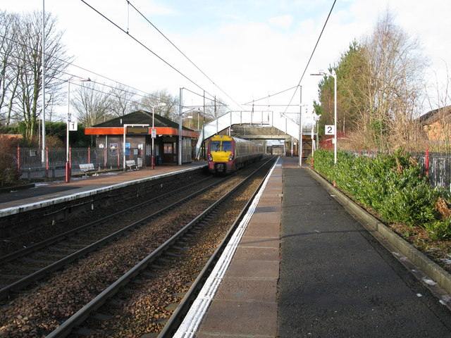
The original Geograph record for G Laird’s 2010 station photograph is preserved separately from the Commons copy; it is the same image and provides original-item provenance, not an additional historical view. geograph blantyre railway station 2010 followup
Station views across time
The 1961 photograph above shows the station before these later views.


Related
- High Blantyre railway station
- Hamilton and Strathaven Railway at Blantyre
- Low Blantyre and the Works village
- Blantyre Cotton Works and Works Village
- Blantyre Colliery
- Glasgow Road, Blantyre
- Historical maps of Blantyre
- timeline