A parish hamlet and estate landscape
The c.1835 New Statistical Account provides an earlier count from a landward enumeration made about 1832, explicitly excluding Blantyre Works: Auchinraith had 24 families and 106 people, 52 of them under fifteen. Samuel Lewis's 1846 gazetteer treats Auchinraith as a hamlet within the historic parish and Middle Ward of Lanarkshire, east of and a short distance from Blantyre village, and gives a population of 77. Lewis associates it with the Alston family's seat. The later figure is lower, but different dates, source purposes and enumeration methods mean this should not be represented as a demonstrated population decline. Both counts distinguish Auchinraith from the mill settlement and the parish centre; neither defines a present-day neighbourhood boundary. lewis topographical dictionary blantyre 1846 The historical parish of Blantyre Blantyre population, 1755–1951 New Statistical Account, c.1835 · Digitised 1846 gazetteer
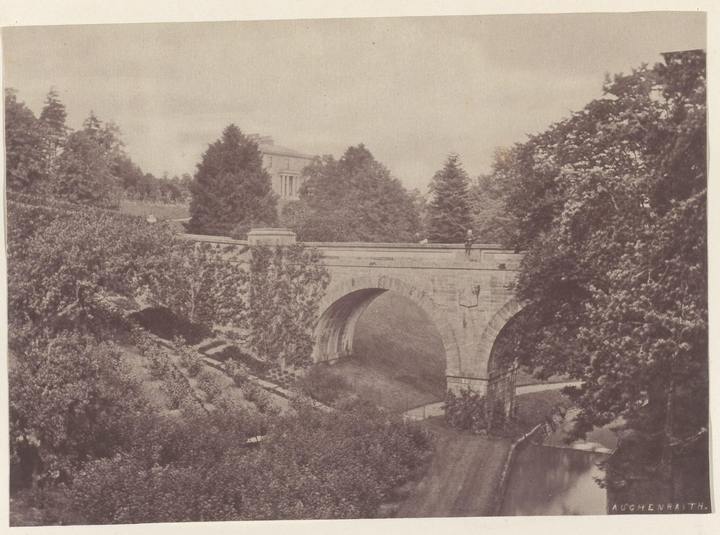
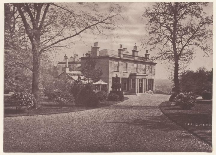
The estate house was known as Auchinraith House and, in an earlier phase, the Grove or Whistleberry. A local-history account attributes the house visible in a photograph captioned 1870 to architect David Hamilton and dates its construction to 1809, replacing the older house across Park Burn. The Rijksmuseum independently catalogues a Thomas Annan photograph of Auchinraith House, object RP-F-2001-7-426-3, as circa 1868 to in or before 1878 and marks the print public domain. It may be the same image as the local reproduction, but the files have not been visually compared; use the museum's date range pending that check. It traces eighteenth-century ownership to the Coulter family, including Glasgow merchant John Coulter, and later owners William Lockhart, Robert Douglas Alston, Alexander Glasgow, Robert Kerr and George Lamb. The account itself gives an unresolved chronology: it says Alston acquired Auchinraith in 1831 but also says Glasgow purchased it in 1846 and sold to Kerr in 1852. These claims should remain attributed until estate deeds, sasines or valuation rolls establish the sequence. The house was later used for education and is reported to have been demolished in the mid-1930s; the exact demolition year remains unverified. The c.1835 parish account independently describes “R D Alston of Auchinraith” among local country-seat owners, supporting Alston's presence in the locality by that date but not the reported 1831 acquisition. blantyre project auchinraith house coulters rijksmuseum thomas annan auchinraith house Blantyre Project, “Auchinraith House & The Coulters”
From sawmill and colliery to industrial settlement
Auchinraith's nineteenth-century economy was not exclusively mining. Naismith’s 1878–79 directory lists Davidson’s sawmills at Auchinraith, placing a sawmilling business there in the late nineteenth century, although it gives no workforce or address more precise than the locality. A local topical index also identifies Robert Davidson as owner of Auchinraith Sawmills in 1847, but the two listings do not establish continuity between the 1847 and 1878–79 references. Contemporary gazetteer coverage describes a wider parish economy of farming, cotton manufacture, coal and ironstone extraction. The directory does not specify the mill’s exact site, scale, workforce or operating span. naismith 1878 79 industrial directory followup Blantyre Project topic index · Lewis, 1846
Mining transformed the locality. The Scottish government's Mineral Statistics for 1884 lists Auchinraith Colliery under Merry & Cuninghame, with William Wilson as manager. It distinguishes No. 1 Pit, working the Ell seam, and No. 2, listed against the Main, Pyotshaw and Splint seams. This is a direct annual snapshot rather than a complete operating history. The Durham Mining Museum's compiled entry reports a workforce of 450 in 1894, 503 in 1900, 574 in 1905, 493 in 1910, 400 in 1915 and 731 in 1920/23. The colliery's wider chronology, accident evidence and housing context belong with Blantyre Colliery and Miners’ housing and rows in Blantyre. mineral statistics scotland 1884 auchinraith durham mining museum auchinraith colliery
The 1930 explosion at No. 1 Pit was a later, closely documented episode in this mining locality. The official report describes Merry and Cuninghame’s Blackband Seam workings, about 750 yards from the shafts, and identifies Dunsmuir’s Section as the place of the blast. It records six deaths and eight injured men, along with unresolved differences in later accounts over Richard/Robert King and John Wildman’s injury status. A funeral photograph published by a local-history project is captioned at Auchinraith Road and Craig Street, providing a visual clue to the route and crowd geography, though its reuse rights are not granted. The colliery closed on 16 August 1931. Local accounts and MineArchive give estimates from over 300 to 350 jobs affected and report that the seams were exhausted; no closure notice or payroll has been examined. The Durham Mining Museum employment sequence records 450 workers in 1894, 400 in 1915 and 731 in 1920/23, but these selected snapshots cannot establish the closing workforce. A later account says the Scottish Co-operative Wholesale Society declined to buy the mine after an engineers’ report in August 1931; the minutes and report remain unlocated. Its plant was auctioned from 15 March 1932, reportedly in about 400 lots including workshop, rescue, electrical and office equipment. Merry and Cuninghame appeared as “in liquidation” in a 1933 directory transcription, while a search excerpt from a 1983 industrial-history article reports completion by July 1936, cites company file SRO BT2/444 and gives Auchenraith Colliery realisations of £10,531, though the article itself remains only partly accessible. The evidence distinguishes mine closure, asset sale and company winding-up; some details remain secondary and partly inaccessible. Auchinraith Colliery disaster of 1930 Blantyre Co-operative Society durham mining museum merry cuninghame company MineArchive 1932 sale account auchinraith mines department report 1931 Mines Department report, digitised text · Blantyre Project funeral photograph caption
The 1891 miner study's documentation places Auchinraith in its own Blantyre enumeration district, 624/2. In the same parish dataset, Auchentibber, High Blantyre, Stonefield, Low Blantyre, Blantyreferme, Dixon's Rows, Baird's Rows/Craighead and Springwell receive separate categories. The guide explains that its settlement labels are tied to the study's record and coding scheme; they are not evidence that parish residents consistently used exactly those boundaries in daily life. It offers a valuable cross-section of mining households but not a count of all residents. Blantyre settlement geographies in 1891 mining research UK Data Service, Study 3651 guide
Railway junctions and a documented derailment
The Hamilton and Strathaven Railway served the colliery before the later connecting curves made the railway geography around Auchinraith especially complex. Specialist railway histories distinguish the Caledonian Railway's Auchinraith Junction from a separate North British Railway junction serving the same colliery. The Caledonian curve, authorised in 1872 and again in 1878, opened on 1 May 1882, linking the Hamilton branch at Blantyre Junction with the Hamilton and Strathaven line. Its stated purpose included giving coal trains direct access towards Glasgow without reversal at Strathaven Junction. The North British route also connected the pits to its Blantyre branch. Junction names are sometimes spelt “Auchenraith” in railway records, and should not be confused with the nearby Craighead or Blantyre Junctions. Hamilton and Strathaven Railway at Blantyre railsocot auchinraith junction RAilScot, Auchinraith Junction · RAilScot, Auchinraith Junction (NBR) · RAilScot, Craighead Junction
On 17 July 1880, before the 1882 curve opened, a passenger train from Hamilton Central to Strathaven derailed on the rising line near Auchinraith and High Blantyre. The Board of Trade accident-return summary identifies the 1.55 p.m. train, a gradient of 1 in 66, a curve of 60 chains radius and a speed not believed to exceed 15 miles per hour. It records the engine, tender and five leading vehicles leaving the rails and tumbling down the bank. The inspector considered expansion of rails in very hot weather the probable cause, describing rails under compression and possible buckling; this is the official investigation's conclusion, not a modern engineering reassessment. A local-history account reports more than 100 passengers and 11 injured, but those details have not been independently confirmed from the full report or contemporary newspapers. board of trade high blantyre accident 1880 Board of Trade accident return, 30 October 1880 · Blantyre Project, accident account
Institutions, recreation and later urban geography
Auchinraith also had social, educational and recreational life beyond industrial work. Local photographic captions identify an 1880 Congregational Church on Craig Street, an 1883 Auchinraith Nursery and curling at Whistleberry near Park Burn in 1898. These captions establish subjects for further archival research, but by themselves do not document the church's denomination history, nursery's proprietor or the organisation and membership of the curling activity. The 1952 parish account names Auchinraith Primary School among local schools, while the Blantyre Co-operative Society's documented bakery and retail premises on Auchinraith Road connected the locality to town-wide retail and distribution. Education in Blantyre Blantyre Co-operative Society blantyre project auchinraith photos Blantyre Project, Auchinraith photo index · Third Statistical Account, 1952
Historic photographs
Related
- Auchinraith Colliery disaster of 1930
- Blantyre Co-operative Society
- durham mining museum merry cuninghame company
- Blantyre, South Lanarkshire
- High Blantyre
- Stonefield, Blantyre
- Hamilton and Strathaven Railway at Blantyre
- Blantyre Colliery
- durham mining museum auchinraith colliery
- Blantyre Co-operative Society
- historical maps